About World atlas & world map MxGeo
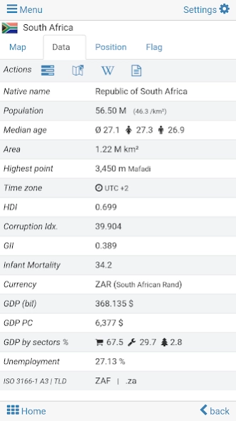
World atlas, world map and educational app for geography. Flags, position maps and basic data about 260 countries and territories of the world. Political maps with regional units and comprehensive economic and statistical...
World atlas, world map and educational app for geography. Flags, position maps and basic data about 260 countries and territories of the world. Political maps with regional units and comprehensive economic and statistical country data for all African countries.
Designed for smartphones and tablets.
• Flags, essential maps and basic data for more than 250 countries and territories of the world
• Search for countries, major cities, rivers, mountains, lakes or coordinates
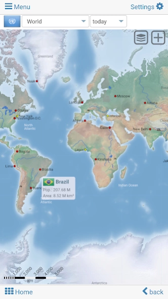
• Interactive political world and continent maps
• Shaded relief layer for world and continent maps
• Geography quiz challenge for playful learning
• Country comparison, favorites and distance calculator
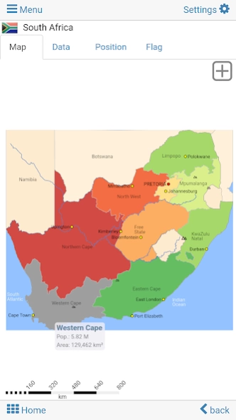
• Comprehensive maps and data of all African countries
• Choropleth maps: area and population
• World clock and distance calculator
• World-explorer: the smallest, largest, ... countries
• No online connection required
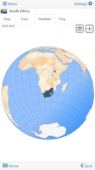
Explore the world by political world and continent maps offline maps. Learn where each country in the world is located. View its position highlighted on a digital globe. Create your favorite color theme or choose from different color schemes for map display.
Do you know the flag of Zambia? Yes? Perfect. Do you also know in which country Mount Kilimanjaro is located? “World atlas & world map MxGeo Free” Quiz helps you acquire a geographic literacy in a playful manner.
Choose from six geo guessing games:
• Test your knowledge about the capitals of Africa
• Do you know the ISO countries codes?
• Recognize the proper country flag based on the outline map
• Do you know the top-level domains of each country?
• Guess the highlighted country on the virtual globe
• Do you know the mountains of Africa?
Geo learning app and educational game which is fun for everyone whether children, adults, seniors or teachers. Get ready for your next stay abroad while enjoying this great world almanac including time zones and statistical data, such as population growth and other key figures. Or prepare for your next geography lesson with this genius digital world map. If not traveling our world atlas lets you explore the world just only virtually.
Free version includes comprehensive data and maps for all African countries. Get “World atlas & world map MxGeo Pro” with detailed data and maps including regional units and capitals for more than 260 countries and territories of the world: Europe, Asia, North America, Africa, Oceania and South America.
Previous Versions
Here you can find the changelog of World atlas & world map MxGeo since it was posted on our website on 2017-01-04 15:24:25.
The latest version is 9.1.2 and it was updated on 2024-04-19 17:36:41. See below the changes in each version.
World atlas & world map MxGeo version 9.1.2
Updated At: 2024-01-09
Changes: • Updates for maps and data
• Bug fixes and improvements
8.x:
• Improved quiz questions choice
• Country comparison and World Explorer new key indicator: population density
• New choropleth map: population density
• Search for countries, major cities, rivers, mountains, lakes and coordinates
• World Explorer: largest cities, longest rivers and highest mountains
World atlas & world map MxGeo version 8.9.8
Updated At: 2023-08-19
Changes: • Updates for maps and data
• Improved quiz questions choice
• Bug fixes and improvements
8.x:
• Updates for Human Development Index (HDI) data
• Country comparison and World Explorer new key indicator: population density
• New choropleth map: population density
• Search for countries, major cities, rivers, mountains, lakes and coordinates
• World Explorer: largest cities, longest rivers and highest mountains
World atlas & world map MxGeo version
Updated At: 2022-11-16
Changes: • Updates for maps and data
• Updates for Human Development Index (HDI) data
• Bug fixes and improvements
8.x:
• Country comparison and World Explorer new key indicator: population density
• New choropleth map: population density
• Search for countries, major cities, rivers, mountains, lakes and coordinates
• World Explorer: largest cities, longest rivers and highest mountains
World atlas & world map MxGeo version
Updated At: 2022-03-11
Changes: . Corrections and updates for maps and data
. Bug fixes & improvements
. Search for subdivisions like states or provinces
6.x:
. Search for countries, major cities, rivers, mountains, lakes and coordinates
. World Explorer: largest cities, longest rivers and highest mountains
. Quiz: Federal states for selected countries
. Distance calculator: more cities
World atlas & world map MxGeo version
Updated At: 2021-10-24
Changes: . Search for subdivisions like states or provinces
. Corrections and updates for maps and data
. New Quiz: the longest rivers
6.x:
. Search for countries, major cities, rivers, mountains, lakes and coordinates
. World Explorer: largest cities, longest rivers and highest mountains
. Quiz: Federal states for selected countries
. Distance calculator: more cities
World atlas & world map MxGeo version
Updated At: 2021-07-06
Changes: . Search for countries, major cities, rivers, mountains, lakes or coordinates
. World Explorer: largest cities, rivers and highest mountains
. Corrections & updates for maps and data
. Bug fixes & improvements
6.x:
. Country data now including info about government type, climate and date of independence
. Distance calculator: more cities
. Virtual World Tour
World atlas & world map MxGeo version
Updated At: 2020-10-12
Changes: . New: search for countries, major cities, rivers & mountains or coordinates
. Corrections & updates for maps and data
. Bug fixes & improvements
6.x:
. Country data now including info about government type, climate and date of independence
. Distance calculator: more cities
. Virtual World Tour
5.x:
. Temperature data: Centigrade or Fahrenheit
. Country data and time zones update
. New key figure HDI in World Explorer
World atlas & world map MxGeo version
Updated At: 2020-07-03
Changes: . HDI 2019
. Corrections & updates for maps and data
. Bug fixes & improvements
6.2.x:
. Dynamic scale bar
. Country data now including info about government type, climate and date of independence
. Distance calculator: more cities
. Virtual World Tour
5.x:
. Temperature data: Centigrade or Fahrenheit
. Country data and time zones update
. New key figure HDI in World Explorer
World atlas & world map MxGeo version
Updated At: 2020-04-12
Changes: . Bug fixes and improvements
. Corrections and updates for maps and data
6.x:
. New: dynamic scale bar
. New: country data now including info about government type, climate and date of independence
. Distance calculator: more cities
. Virtual World Tour
5.x:
. Temperature data: Centigrade or Fahrenheit
. Country data and time zones update
. New key figure HDI in World Explorer
World atlas & world map MxGeo version
Updated At: 2019-12-11
Changes: . Corrections and updates for maps and data
. Bug fixes and improvements
6.x:
. New: dynamic scale bar
. New: country data now including info about government type, climate and date of independence
. Distance calculator: more cities
. Virtual World Tour
5.x:
. Temperature data: Centigrade or Fahrenheit
. Country data and time zones update
. New key figure HDI in World Explorer
Disclaimer
Official Google Play Link
We do not host World atlas & world map MxGeo on our servers. We did not scan it for viruses, adware, spyware or other type of malware. This app is hosted by Google and passed their terms and conditions to be listed there. We recommend caution when installing it.
The Google Play link for World atlas & world map MxGeo is provided to you by apps112.com without any warranties, representations or guarantees of any kind, so access it at your own risk.
If you have questions regarding this particular app contact the publisher directly. For questions about the functionalities of apps112.com contact us.